Every time threatening weather approaches Grant County, Minnesota, Emergency Management Director Tina Lindquist has a gut-wrenching decision to make. While taking steps to prepare for the unknown and inform the public, Lindquist also works with the six volunteer fire departments and the local sheriff’s office as they decide whether and where to deploy their network of more than two dozen volunteer spotters. Increasingly, she worries that she does not have all the information she needs to keep them out of harm’s way. So, she is now leading an effort to change that – for her fellow emergency responders and the public they serve.
To illustrate the threat, Lindquist points to May 2022. Twice that month, derechos – devastating, long-lived wind storms – swept across Minnesota, leaving damage in their wake. In advance of severe storms, Lindquist works with responders and dispatch to ensure response plans are ready to be set in motion. Two dozen or more firefighters and other emergency crews – almost all volunteers – fanned out across the area.
Resource Deployment Decisions
Choosing the right locations is critical for multiple reasons. Crews need to spread out so they can rapidly deploy wherever needed. They must also distribute equipment to reduce the likelihood of simultaneously damaging assets. Most importantly, the team focuses on keeping the responders safe. “Our volunteer responders are the heart of our community,” said Lindquist. “They’re the first group to step up because they’re passionate about keeping their neighbors safe. We want to help them make good decisions.”
Even when storms like derechos cover huge areas and are forecast well in advance, the targets facing the highest intensity and danger constantly shift. That kind of activity is challenging for the team to track. Grant County sits in a diamond-shaped area of Minnesota so far removed from National Weather Service Radars in the Twin Cities, Duluth, and the Dakotas that the radar beams are at 10,000 feet or higher by the time they reach this part of the state. Meteorologists and emergency responders cannot see what is happening at lower altitudes, where conditions can quickly turn deadly.
“Warnings were spotty,” Lindquist said of the May 2022 storms. “And even when there were warnings issued, there were plenty of dangerous conditions outside the warned areas.” For emergency responders, the results were terrifying and tragic. There were reports of high winds lifting volunteer responder vehicles off the ground and moving them into nearby fields. Miraculously, those responders walked away uninjured. However, in nearby Kandiyohi County, Ryan Erickson, a former fire chief with more than 40 years of experience, died when a silo blew over onto his vehicle.
“Tell me how you feel if you’re the person making the decision to send out spotters,” said Lindquist, whose 20-year-old son is training to be a volunteer responder. “It isn’t safe sending responders out if we don’t know what we aren’t seeing.”
Winter weather is even more difficult for weather radars to pick up at a distance, which is incredibly challenging for emergency managers in northern states like Minnesota. Lindquist pointed to a snowstorm that hit the night before Christmas Eve 2022, stranding many motorists in Kandiyohi County as roads became impassable. When rescued, most said they had looked at the radar before leaving home, and it did not show any impactful weather.
Minnesota emergency managers also experienced the gaps firsthand in February 2023. As they gathered near Minneapolis for a statewide conference, severe winter weather moved into the Twin Cities. As officials left the event to drive home across the state, they traveled through heavy winter weather the entire way, most of which never appeared on the radar. “TV stations were reporting one inch or more of snow falling an hour from the Metro to St. Cloud (about an hour away), but they had no idea how bad conditions were farther out,” Lindquist remembered.
Working Toward Closing Radar Gaps
Lindquist and others have formed a workgroup as part of the Association of Minnesota Emergency Managers. Their mission is to fill the radar gaps, which typically involves expensive technology. Most local governments cannot afford to buy and maintain their own radar systems, and the National Weather Service has not installed a new Next Generation Weather Radar (NEXRAD) since 1997. The group has also considered looking outside the government.
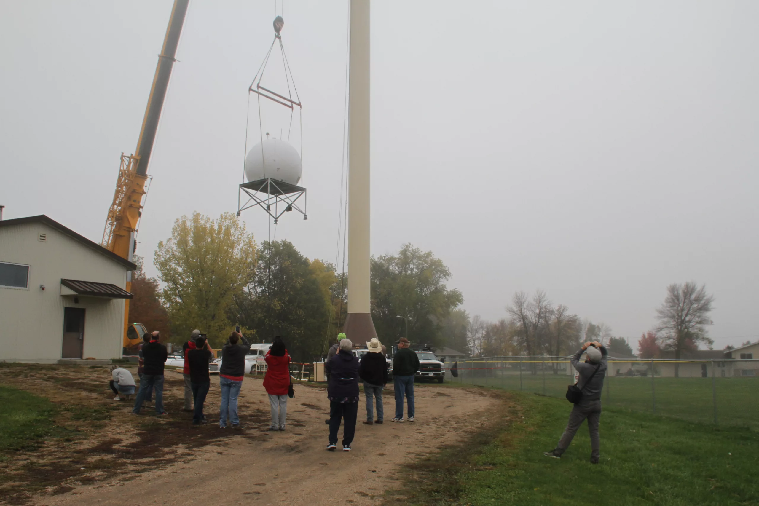
For example, Grant County has just partnered with a commercial weather tech company to install a new, high-resolution radar on top of a water tower in Wendell. The company is taking on the burden of ownership – they fund it, operate it, maintain it, and then provide the data to private clients, but Lindquist’s team of responders in Grant County will also have access at no charge. “This will be the first time we’re getting a real visual radar picture of what’s happening on the ground in our area – and in the counties to our north, south, east, and west,” Lindquist said. “It will help not only our emergency responders but also public works and the community as a whole.”
In November 2023, the U.S. House Committee advanced the Weather Act Reauthorization (H.R. 6093), which encourages public-private partnerships. The bill is moving toward a floor vote and then to the Senate. However it happens, plugging the gaps will benefit both rural and urban areas. Positioning emergency resources can be more complex in heavily populated areas, so providing data as storms are approaching through rural areas can be critical. Better data will also help serve urban residents as they travel into and through places like Grant County, whose population can sometimes double with resort and recreational traffic.
“Our partnership with the National Weather Service is extremely important to us,” Lindquist said. “By no means are we dissatisfied with them. We want to help them. The more eyes on the sky, the better – that’s how we feel about this.” While officials explore the different types of radar technologies and possible plans for the state, she said the most important thing is for the public to realize radar gaps exist.
There are so many tools, such as digital applications and media platforms, available to communities today to help crowd-source official alerts, warnings, and even highly localized information about real-time weather situations. While these forums are helpful for reporting current impacts, they are most beneficial when used in conjunction with all of the pre-planning briefings and opportunities that the National Weather Service provides. When paired together, these information innovations help complete the weather picture, especially in the lower levels of the atmosphere. With so many mobile weather applications, people can get a false sense of security when they do not see any storms on their screens. “Just because the radar can’t see a storm doesn’t mean it isn’t there,” Lindquist said. “You don’t know what you don’t know.”

Tara Leigh Goode
- Tara Leigh Goodehttps://www.domesticpreparedness.com/author/tara-leigh-goode


