Geographic information systems (GIS) have become standard tools used for addressing large-scale disasters. Following the 2010 earthquake in Haiti, the 2011 tsunami in Japan, and the fast-moving tornado in Moore, Oklahoma, earlier this year, GIS and other geospatial technologies helped relief workers prioritize their efforts, supported natural resource assessments, assisted in insurance and damage assessments, and provided officials with the data they needed to make crucial decisions.
The common denominator in these and other applications is that all of them involve interrelated aspects of remediation and repair operations. However, although geospatial technologies are a major asset during the rescue and restoration phases of an operation, they also can play an important role before disaster strikes. As a proactive tool, for example, GIS has helped not only to develop and improve community resilience to disasters and dangers of all types but also to prepare communities, disaster professionals, first responders, government agencies, and private citizens to deal more effectively with the potential consequences of specific disasters.
The shift from reaction to anticipation encompasses three major areas of emphasis: documentation, threat identification, and evacuation and relief planning. Following are a few specifics about each.
Documentation – Comparing the Before & After
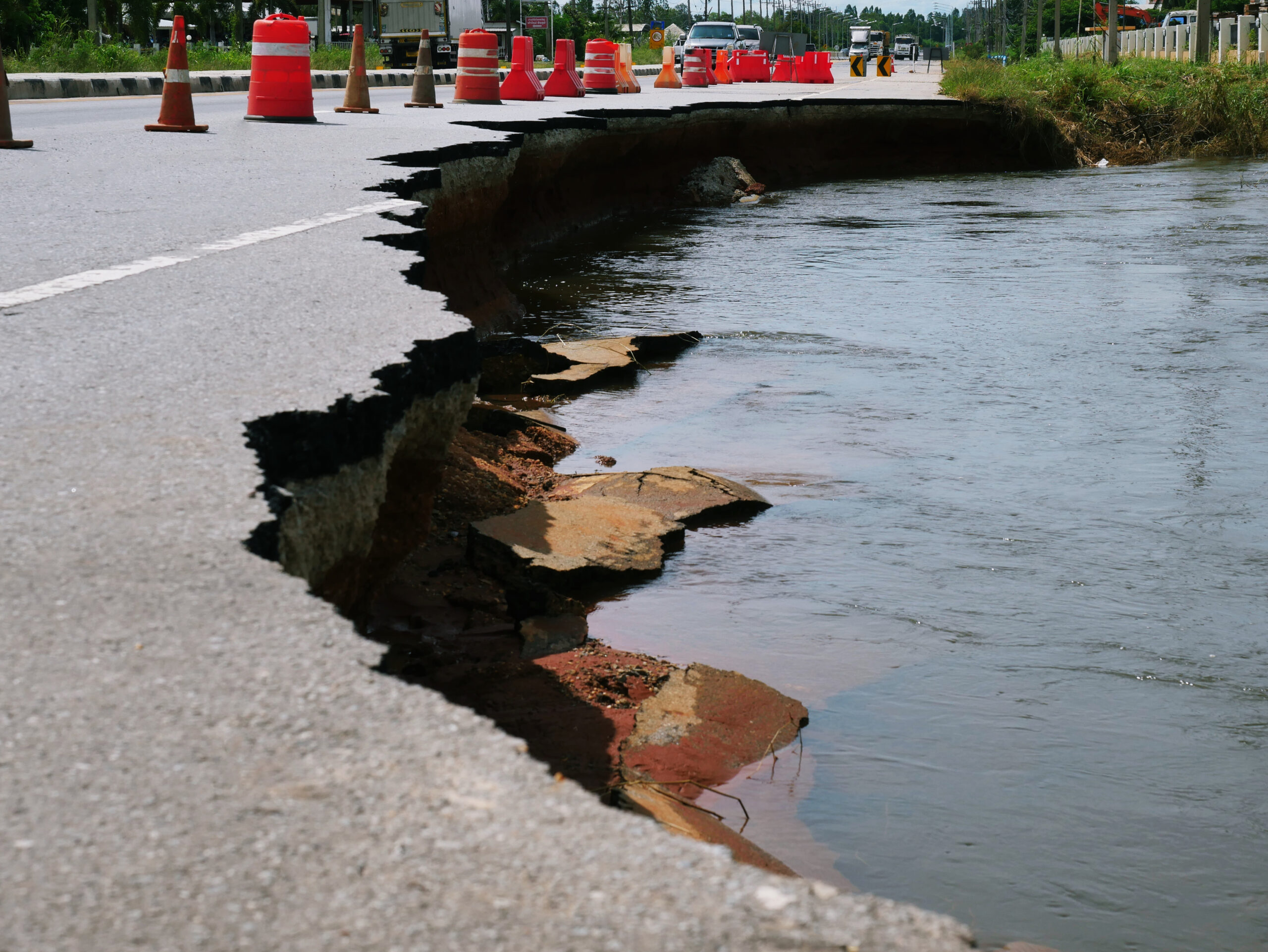
When a disaster transforms what was once familiar into the unfamiliar, the ability to pinpoint the location of essential resources can be a major challenge for responders. Violent forces of nature – typhoons, earthquakes, etc. – have the ability to totally reshape landscapes and destroy well-known landmarks, leaving even local residents disoriented. The floods caused by Hurricane Irene in 2011, to cite but one example, washed away several roads and even shifted the courses of some rivers in New England.
In addition, after-action reports about various tornadoes that have devastated several areas in the U.S. Midwest over the past several years described the unforeseen ways in which entire blocks of homes and businesses were completely destroyed, making navigation through a devastated neighborhood always difficult and sometimes impossible. Knowing in advance where various “things” are or were is, therefore, the first and perhaps most important step that must be taken before any effective action can be initiated after a major natural disaster. Among the key initial tasks that must be carried out are: (a) locating utility poles (for electrical crews); (b) identifying hydrants and/or other reliable sources of water (for firefighters); and (c) avoiding natural gas pipes, water mains, and electrical cables – particularly when construction crews are digging.
Traditional maps are static and show an area of a specific city or town only as it previously appeared. By combining a GIS database with critical related information and global positioning systems (GPS) to determine a more precise location, emergency crews can be helped to maneuver their way through what might otherwise be simply piles of rubble, tree branches, and other debris. Moreover, rather than working with only pre-disaster information available, a GIS system that can deliver additional and/or updated information to mobile devices as quickly as possible can provide emergency personnel with visuals of the same area overlaid with images of current conditions. Important and/or visually prominent features, natural resources, and potential dangers could be highlighted to help emergency crews work safely and more efficiently.
Threat Identification – Beyond Terrorism & Security
For a response team, being spatially oriented within a specific geographical area is a vital step in coping with a natural disaster or any other type of emergency situation. But any response effort will undoubtedly be stronger if more time has been taken in advance to anticipate a potential problem and to plan accordingly. In that context, it should be emphasized that specific threat identification – although usually associated with terrorism and security issues – is actually a broader concept that also can be used as a powerful tool for advanced readiness. Even a weather report is, in a sense, an early warning system for potentially adverse meteorological events.
GIS provides substantial sophistication and nuance to any type of threat identification – weather, for example. Almost all weather forecasts offer general predictions of the most likely weather conditions that can be expected over a fairly large land area in the next several hours or even days. But most actual weather events affect each smaller area within the large area in at least somewhat different ways, depending on such variable factors as the ground cover involved, the type and location of local drainage systems, the sewer or septic services available, ground stability, the structural design of large buildings, and land use. Because each and all of these factors vary dramatically over distances as short as a few feet, the impact of weather on two places relatively close to one another may differ significantly in terms of flooding, wind and heat conditions, and the potential damages likely in the aftermath of a major storm.
For all of these reasons, it is imperative that well-prepared community and response teams have a clear sense, to the utmost degree possible, of oncoming danger – whether or not that danger is caused by natural conditions, industrial accidents, and/or human intervention. To prepare for any and all of these dangers, GIS models deliver capabilities that: (a) show, in geographic detail, several ways in which various scenarios might play out; and (b) then provide impact updates as an event unfolds.
GIS models take into account such variables as terrain, building plans, and even some rapidly changing factors as high winds. Modeling can identify relatively small differences that can send a major fire in one direction, for example, thereby allowing decision-making officials to position their resources accordingly. Modeling also can show the level at which a certain amount of rain or surface water overflow would cause sewers to back up, which would suddenly push the flooding danger into high gear. The basic rule to remember is that, the more information that is available, the more effectively responders and decision-makers can react.
Evacuation & Relief Planning – Building on a Solid Foundation
The third leg of the GIS readiness tripod is evacuation and relief planning. Under particularly adverse conditions, it may become necessary to evacuate residents from any given neighborhood. But different types of events might require different types of evacuation. An industrial accident at a power plant, for instance, might release hazardous materials that, given an uncertain wind or storm pattern, would make travel in a particular direction more dangerous or even impossible. To make evacuation planning more effective and more comprehensive in scale, such planning should ideally be initiated in conjunction with full threat identification and modeling. Later, as the specifics of any given threat become clearer, the most appropriate evacuation plan can be determined.
In a similar way, resilience means the ability to recover and recuperate from trouble – but that ability requires that the proper resources are brought to bear, as quickly and safely as possible. Whether already locally positioned or transported into the affected area, those resources must be moved along the fastest and safest path available. Again, thanks to the help of GIS, planners also can develop efficient reverse-evacuation routes, using such factors that can be tracked within the system as: (a) the size, nature, and number of delivery vehicles; (b) the weight limits for certain roads (including those with potentially degraded conditions); (c) the clear travel paths most likely to be available; and (d) the most efficient pre-staging locations that should be used.
As with the evacuation plans mentioned earlier, the transport of needed resources requires the use of real-time updates on what might well be changing weather or other conditions. However, with the bulk of the groundwork already done, officials usually would be able to concentrate their attention on a flexible adaptation of strategies rather than creating a new response plan to cope with a new threat.
The GIS Readiness Tripod
Without full documentation of an area created in advance of a disaster, emergency and relief personnel must work with blinders on. Threats that are recognized only upon arrival restrict the ability of emergency teams to respond in a coherent and effective manner. Moreover, the logistics of evacuation and the transportation of relief resources can vary significantly, depending on the nature of the disaster and how it unfolds.
The most important aspect of creating a resilient community is being as prepared as possible, as early as possible, so that response and recovery personnel do not lose unnecessary time while making decisions and altering general strategies when the clock is already ticking. Because unforeseen events and responses often are deeply affected by geographic specifics, the use of GIS adds a helpful degree of insight, specificity, and flexibility – important albeit unquantifiable variables that are not possible, to the same extent, with the use of strictly conventional tools.

Stephen McElroy
Stephen McElroy, GIS program chair at American Sentinel University, has been in the GIS field for more than 15 years, working as a GIS technician for the U.S. Department of Agriculture, Agricultural Research Service, Southwest Watershed Research Center, and as a senior research specialist for the Udall Center for Studies in Public Policy and the Department of Soil, Water, and Environmental Sciences at the University of Arizona. He holds a Ph.D. in geography from the joint doctoral program at San Diego State University and the University of California, Santa Barbara, and a certification from the GIS Certification Institute.
-
This author does not have any more posts.